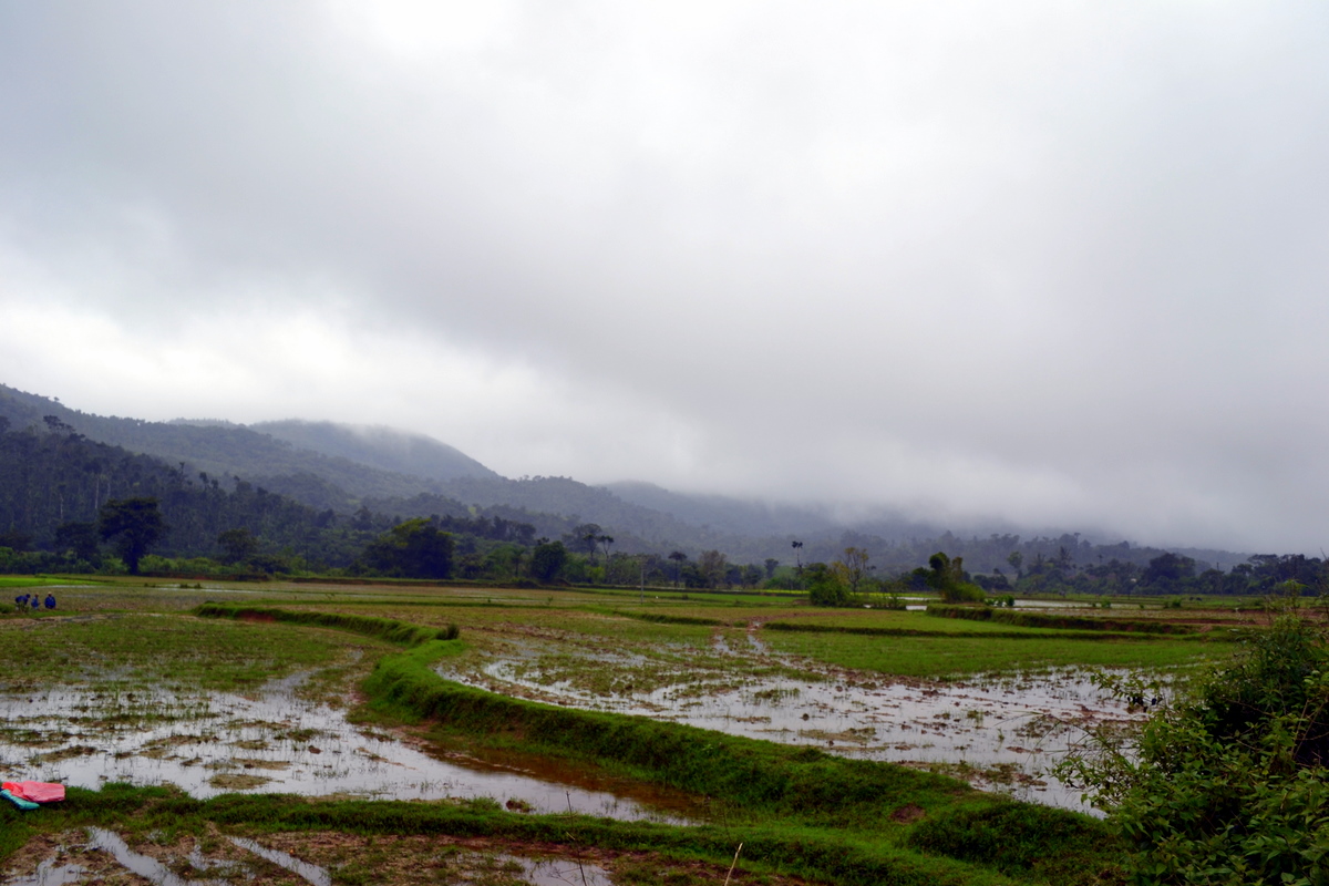
This is time for Indian Monsoons. This is also the best time to see Western ghats and experience rain especially in the Malnad region of Thirthahalli in Karnataka. It is still unexplored and receives the second highest rainfall in India. This is THE place for someone who wants to experience Indian monsoons in full glory.
I would recommend you to make Thirthahalli as base (Thirthahalli ) - it is centrally located and has good stay options - and you can comfortably plan for four to five days of outing. It is a sleepy little town in rural Karnataka. Thirthahalli and its surroundings is also an area which receives heavy rain fall.
Having been to Thirthahalli and surroundings many times, here is a recommended itinerary. Of course, this region can be visited throughout the year if you don't want to get wet in the torrential rain! The season between October to March is the best when there is a nip in the air, mist on the mountains and a chance to see glorious sunrises and sunsets.
This itinerary is basically for a road trip from Bangalore. If you don't intend to drive, don't worry. You have an excellent option of taking a night train from Bangalore to Shimogga and ask your host to arrange for a pick up at Shimoga railway station. Shimoga to Thirthahalli is a beautiful and picturesque drive of an hour. If you are a person who loves bus journeys, you have option to catch a direct night bus from Bangalore to Tirthahalli.
Day 1 - Bangalore - Thirthahalli
Total Distance - 339 KMs
Route Map - Bangalore - Tirthahalli
Amritapura - Amrutesvara Temple, Amruthapura - Wikipedia, the free encyclopedia
Day 2 - Tirthahalli - Kundadri - Agumbe - Thirthahalli
Total distance - 80 KMs
Route Map - Tirthahalli - Kundadri - Agumbe - Tirthahalli
- Leave Bangalore in the morning and reach Tirthahalli for Lunch.
- It is a comfortable six hours drive.
- Have breakfast enroute either at Tiptur (Kamat Restaurant) or Arsikere (Raghavendra Lodge) or Kadur (Vinayaka Cafe) or Birur (Preethi Canteen).
- On the way visit Amritapura - five KMs from Tarikere - for its famous Hoysala temple.
- In the evening go around Tirthahalli town, visit Bheemanakatte for a quiet evening by Tunga river.
Amritapura - Amrutesvara Temple, Amruthapura - Wikipedia, the free encyclopedia
Day 2 - Tirthahalli - Kundadri - Agumbe - Thirthahalli
Total distance - 80 KMs
Route Map - Tirthahalli - Kundadri - Agumbe - Tirthahalli
- Experience the fury of rain and wind on Kundadri - A Small hillock on the way to Agumbe. You can drive up the hill and enjoy panoramic view. You may take a look at Kundadri pictures in my earlier post on Monsoon drive.
- Visit Agumbe Rain Forest research station and learn about King Cobra and wild life in Western Ghats
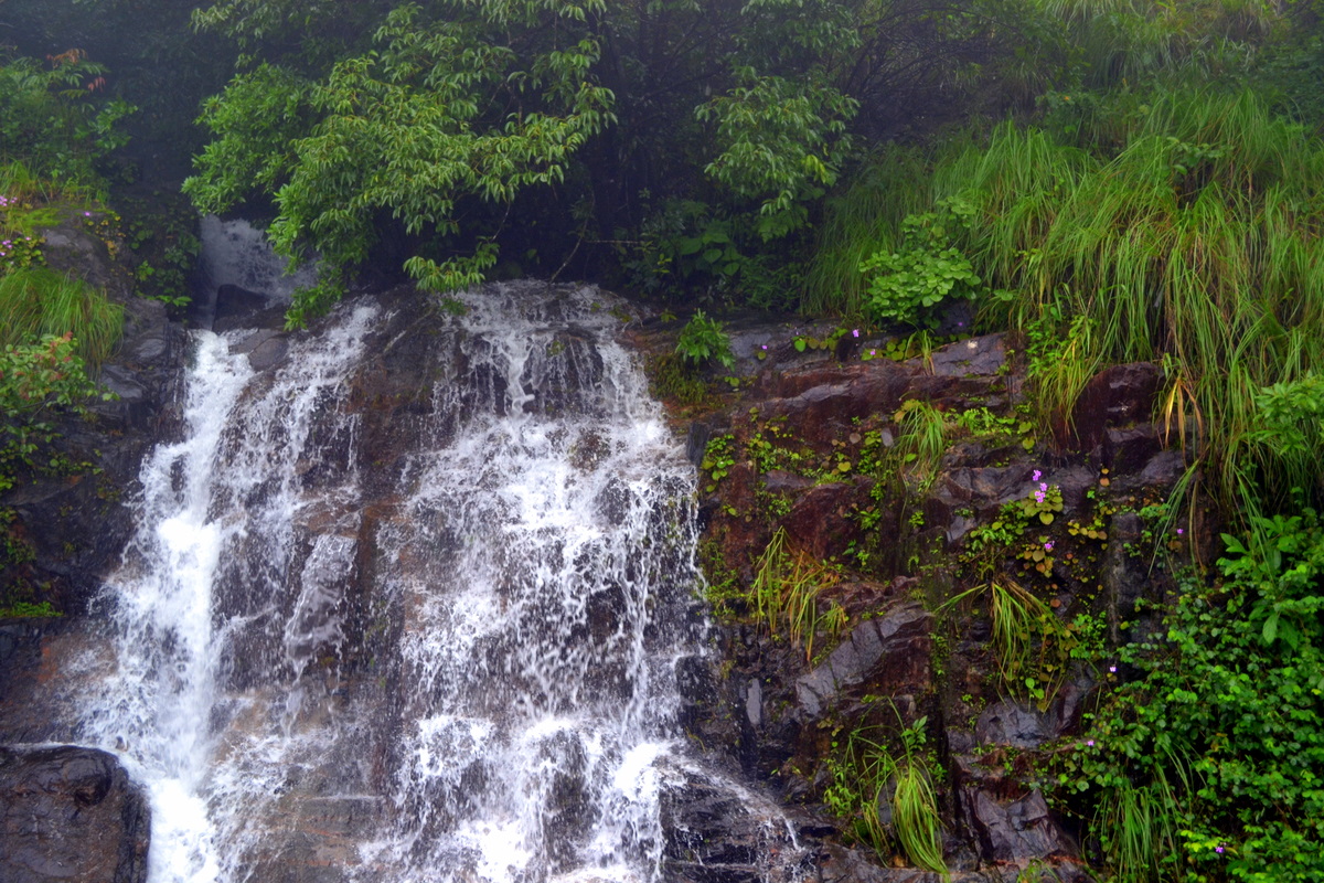
- Enjoy the cascades of Jogi gundi and Koodlu Theerta waterfalls
- Walk on the streets where Swami and his friends walked in Malgudi Days
- Return back to Tirthahalli in evening.
- You may not be able to see beautiful sunset at Agumbe during monsoons which is possible in winters and summer
Useful links
More Kundadri pics - deepsan: Magical morning at Kundadri Betta
Agumbe - Agumbe - Wikipedia, the free encyclopaedia
Agumbe Rainforest research station - ::.Agumbe - Rainforest Research Station
Malgudi Days - Malgudi_Days
Day 3 - Thirthahalli - Sringeri - Horanadu - Kuppali - Thirthahalli
Total distance - 185 KMs
Route map - Tirthahalli - Sringeri - Horanadu - Tirthahalli
Kuppali - Kuppalli - Wikipedia, the free encyclopaedia
KUVEMPU - Kuvempu
Sringeri - Shringeri - Wikipedia, the free encyclopedia
Day 4 - Thirthahalli - Kollur - Thirthahalli
Total distance - 167 KMs
Route map - Tirthahalli - Kollur - Tirthahalli
Total distance - 114 KMs
Route Map - Tirthahalli - Kavaledurga - Mani Dam - Nagara Fort - Tirthahalli
KavaleDurga - The Voice of Greenery: Kavaledurga
YouTube Video on Kavaledurga
Mani Dam - The Voice of Greenery: Kavaledurga
Nagara Fort
More Kundadri pics - deepsan: Magical morning at Kundadri Betta
Agumbe - Agumbe - Wikipedia, the free encyclopaedia
Agumbe Rainforest research station - ::.Agumbe - Rainforest Research Station
Malgudi Days - Malgudi_Days
Day 3 - Thirthahalli - Sringeri - Horanadu - Kuppali - Thirthahalli
Total distance - 185 KMs
Route map - Tirthahalli - Sringeri - Horanadu - Tirthahalli
- A beautiful drive.
- Have early breakfast in the place of your stay or better have a good South Indian breakfast at Sringeri. Visit historical temple of Goddess Sharada
- Walk over the bridge on Tunga river and visit Shankaracharya's Ashram - don't miss seeing Award winning architecture of Sanskrit Pathashala.
- Drive to Horanadu. Visit the famous temple of Goddess Annapoorneshwari at the foot hills of mountains
- Have lunch in temple.
- After lunch drive back to Tirthahalli and on the way after Koppa, visit the beautifully restored heritage house of great Kannada poet KUVEMPU as a memorial for him at Kuppali - good signage is there. Trek to "Kavi Shyla" a small hill - ten minutes trek - adjoining to the memorial to see "Stone Henge" kind of structure done by well known artist K T Shivaprasad.
- Enjoy the beautiful view of Sahyadris from the top.
- Return back to Tirthahalli
Kuppali - Kuppalli - Wikipedia, the free encyclopaedia
KUVEMPU - Kuvempu
Sringeri - Shringeri - Wikipedia, the free encyclopedia
Day 4 - Thirthahalli - Kollur - Thirthahalli
Total distance - 167 KMs
Route map - Tirthahalli - Kollur - Tirthahalli
- After early breakfast drive to Kollur.
- Enjoy the beautiful drive through mountains/valleys
- Visit temple dedicated to Goddess Mookambika.
- Return to Tirthahalli for late lunch
Total distance - 114 KMs
Route Map - Tirthahalli - Kavaledurga - Mani Dam - Nagara Fort - Tirthahalli
- Kavaledurga is a hillock fort close to Tirthahalli with amazing views of Mani dam backwaters and valleys.
- After break fast head towards Kavaledurga.
- Climb the the hill fort - it has steps - enjoy the views.
- Drive to Nagara fort
- Drive to Mani dam on the way back and view beautiful backwaters formed by the dam.
- Return to Tirthahalli for late lunch.
- After lunch and rest visit Chippalagudde, a picnic spot on Tunga river
KavaleDurga - The Voice of Greenery: Kavaledurga
YouTube Video on Kavaledurga
Mani Dam - The Voice of Greenery: Kavaledurga
Nagara Fort
Route Map - Tirthahalli - Kodachadri
Kodachadri - The Voice of Greenery: Search results for kodachadri
Day 7 - Thirthahalli - Mandagadde bird sanctuary - Sakrebylu elephant camp - Gajanur dam - Tyavarekoppa Lion safari - Thirthahalli
Total distance - 140 KMs
Route Map - Tirthahalli - Shimoga - Tirthahalli
Mandagadde - Mandagadde Images
Sakrebylu - Sakrebylu Images
Day 8 - Thirthahalli - Sagara - Jog falls - Thirthahalli
Total distance - 220 KMs
Route map - Tirthahalli - Jog Falls - Tirthahalli
- Trekking of Kodachadri in Monsoons is only for experienced trekkers.
- Also visit beautiful Hittalamane falls at the foot hills.
- In non monsoon season, one can enjoy amazing sunset from this peak.
Kodachadri - The Voice of Greenery: Search results for kodachadri
Day 7 - Thirthahalli - Mandagadde bird sanctuary - Sakrebylu elephant camp - Gajanur dam - Tyavarekoppa Lion safari - Thirthahalli
Total distance - 140 KMs
Route Map - Tirthahalli - Shimoga - Tirthahalli
- This can be done as a comfortable day trip. This trip is specially for Kids who will enjoy bathing elephants and see lions and tigers at close quarters.
- Leave early with packed breakfast.
- Visit Sakrebylu elephant camp. Watch how the mahouts bathe and train elephants. Allow kids to play with some baby elephants including bathing them
- After breakfast, drive to Tyavarekoppa lion safari which is ten KMs from Shimoga. On the way stopover at Gajanur dam to enjoy beautiful vistas of backwaters of Tunga river
- Enjoy lion safari and have lunch in Shimoga. Visit Shivappa Nayaka's palace in city.
- Drive back to Tirthahalli.
- Stop over at Mandagadde bird sanctuary on the way for some bird watching
Mandagadde - Mandagadde Images
Sakrebylu - Sakrebylu Images
Day 8 - Thirthahalli - Sagara - Jog falls - Thirthahalli
Total distance - 220 KMs
Route map - Tirthahalli - Jog Falls - Tirthahalli
- After breakfast drive to Jog falls, the tallest water falls in Asia
- On the way back visit famous temple at Ikkeri on the outskirts of Sagara.
- Have lunch in Sagara.
- Return to Tirthahalli
Jog Falls
Wiki - Jog Falls
Google Images - Jog Falls
Ikkeri - Aghoreshvara Temple @ Ikkeri
Day 9 - Return to Bangalore after Breakfast
Interesting Deviations
There are good home stays in and around Tirthahalli which provide nice accommodation with excellent meals. We have stayed at Bananki (www.bananki.com) and the Malnad cuisine served by them is awesome. A very good home stay.
For more stay options, you may visit Travelmalnad which lists home stays in Tirthahalli.
Glossary
Malnad - Is a shortened form of "Maley Nadu" meaning the region with rainfall. "Maley" in Kannada Language means Rain
Western ghats - Mountain ranges in peninsular India. A UNESCO World heritage site.
Hoysala - Medieval dynasty who ruled vast parts of South India. Famous for building artistically brilliant temples.
Malgud Days - Iconic Indian television serial
Ashram - Monastery
Pathashala - School
Sahyadri - Another name for Western Ghats
Mahout - Elephant trainer
Did you like this post? Do you need help in planning a trip to Tirthahalli and Malnad to experience Indian Monsoon? You are welcome to write to me at poorna62@gmail.com.
Happy to help
Wiki - Jog Falls
Google Images - Jog Falls
Ikkeri - Aghoreshvara Temple @ Ikkeri
Day 9 - Return to Bangalore after Breakfast
Interesting Deviations
- If one wants to visit Udupi, then they can deviate from Agumbe or Kollur.
- If one wants to Murdeshwar and beyond, one can do so after Jog falls. Also there is a nice trek of Kanur fort from Jog falls for which one has to stay near Jog falls.
- Tirthahalli and surroundings experience heavy rainfall during monsoon. Take proper rain gear.
- Make sure your car is in good condition. Check condition of tyres.
- Always check locally for latest road condition. Your host will be of help.
- You can hire a car at Tirthahalli for doing different trips.
- Plan your itinerary based on number of days you can spare.
- While trekking or walking in monsoon, you may suffer leech bite. Don't worry. It is a minor hiccup.
There are good home stays in and around Tirthahalli which provide nice accommodation with excellent meals. We have stayed at Bananki (www.bananki.com) and the Malnad cuisine served by them is awesome. A very good home stay.
For more stay options, you may visit Travelmalnad which lists home stays in Tirthahalli.
Glossary
Malnad - Is a shortened form of "Maley Nadu" meaning the region with rainfall. "Maley" in Kannada Language means Rain
Western ghats - Mountain ranges in peninsular India. A UNESCO World heritage site.
Hoysala - Medieval dynasty who ruled vast parts of South India. Famous for building artistically brilliant temples.
Malgud Days - Iconic Indian television serial
Ashram - Monastery
Pathashala - School
Sahyadri - Another name for Western Ghats
Mahout - Elephant trainer
| YTWRR7R2CE7G |
Did you like this post? Do you need help in planning a trip to Tirthahalli and Malnad to experience Indian Monsoon? You are welcome to write to me at poorna62@gmail.com.
Happy to help